 Sun Corridor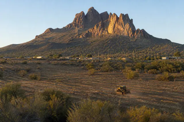
Sun Corridor Land Clearing connects Picacho property owners with a local land clearing contractor for land clearing, brush removal, and lot clearing across the Picacho area.
Picacho is small — 250 residents at the 2020 Census, down by nearly half over the decade — but it holds the corridor's most recognizable ground: the creosote flats running up to Picacho Peak's jagged profile, the historic I-10 waypoint community near the state park entrance, and acreage parcels where the Sonoran Desert is still entirely in charge. Clearing work here is rural, occasional, and conducted under the most photographed horizon in Pinal County.
The parcels are honest desert: creosote and bursage flats with mesquite along the shallow washes, transitioning to saguaro, cholla, and prickly pear where the ground rises toward the peak's rocky bajada. That gradient writes the clearing rules — flats mulch into clean, maintainable ground for homesites and horse setups, while the cactus-bearing slopes are selective-work-only territory where protected plants are flagged plant by plant and machines thread mulched lanes between them.
Fire weighs on this community more than most. The invasive-grass fuel problem is well established along the interstate corridor and around the park, dry lightning arrives every monsoon, and a 250-person community has no margin for an ember event — so defensible-space clearing around Picacho's homes and outbuildings, and fuel management along parcel edges, is the steadiest work the area generates.
Clearing next to a landmark: the saguaro-first method
Parcels near the peak carry the densest protected-plant load in the service area, and the method scales to it: the walk happens first, every saguaro, ironwood, and significant cactus gets flagged and logged, the mulched lanes get planned around them, and hand crews handle the last feet where a machine's swing radius can't be trusted. Arizona's native plant law is the legal floor; on this ground the practical standard is higher, because a cleared parcel under Picacho Peak with its cactus intact is worth more than one without — to the owner and to the view. The park itself, protected ground where the same landscape is preserved outright, is at azstateparks.com/picacho.
Buyers should assume any unfarmed Picacho parcel carries protected plants and budget the survey walk into their clearing plans — it's quick, and it prevents every expensive kind of surprise.
Fuel, wind, and the interstate: Picacho's clearing seasons
This stretch of the corridor is where the region's dust-and-visibility problem is most famous, and where the invasive-grass fire cycle threatens a landscape that never evolved for burning. Both problems answer to the same clearing habits: cut the cured annuals before mid-June, keep buffers held around structures per Firewise zone logic, leave soil crust intact everywhere machines don't strictly need to disturb it, and stabilize anything opened. Fire weather and dust advisories for this end of the map come through the NWS Tucson office.
The reward for the diligence is a parcel that looks like Picacho is supposed to look: open ground, healthy cactus, a horizon with a peak in it, and nothing waiting to burn.
Further reading
Good to know
Can land near Picacho Peak State Park be cleared at all?
Private parcels outside the park boundary, yes — under the same state native-plant law as everywhere, applied here with extra care given the cactus density. The park itself is protected ground. The survey walk establishes exactly what your parcel carries before anything is quoted.
What does rural acreage clearing cost out here?
Flats clear at normal corridor rates; slope ground with heavy cactus runs slower and more selective, so per-acre costs rise with the protected-plant count. Mobilization to Picacho is routine — it's on the service area's main axis — so small jobs remain economical.
Who handles fire buffers for a community this small?
Individual owners, mostly — there's no municipal crew coming. A day of machine work holds a defensible ring around a typical homesite for a year or more, and neighboring owners often book together to share the mobilization.
Are the washes on my parcel workable?
Mesquite along Picacho's shallow washes can be thinned and the crossings hardened, but the channels themselves stay functional — they're the drainage for cloudburst flow off the peak's slopes. Clearing plans respect the paths and armor the crossings.
Does the declining population mean less service out here?
Not for this trade — the route between Chandler-side work and the Casa Grande–Eloy cluster passes Picacho constantly. Small rural jobs slot into that flow easily, which keeps response times short despite the community's size.