 Sun Corridor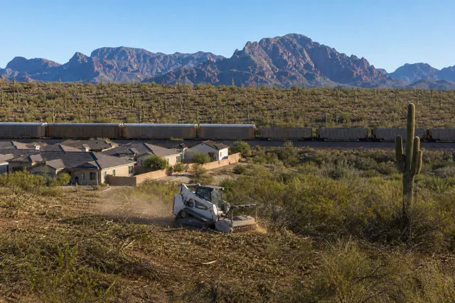
Sun Corridor Land Clearing connects Red Rock property owners with a local land clearing contractor for land clearing, brush removal, and lot clearing across the Red Rock area.
Red Rock is the corridor's southern surprise: a onetime rail siding on the Union Pacific line that the 2020 Census caught mid-transformation at 2,625 residents — up 21 percent in a decade — as master-planned pockets of tile-roofed homes grow out of the creosote between I-10 and the saguaro-dotted ranges to the east. It's the last stop in this service area before Tucson's orbit takes over, and its clearing work has a new-frontier flavor.
The jobs split with the community. Inside the planned pockets, the work is builder-adjacent: phase edges cleared, drainage corridors maintained, common tracts kept mowed, and individual owners finishing their lots' desert edges to sit cleanly against preserved open space. Outside them, Red Rock is still rural Pinal County — acreage parcels of honest Sonoran desert where homesites get carved out under the same saguaro-first discipline as anywhere cactus grows, and where defensible space matters because open desert runs unbroken to the mountains.
The setting adds two constants. The rail line means some parcels border right-of-way with its own vegetation standards and access rules. And the desert here is transitional — denser, more saguaro-rich than the flats further north — so protected-plant surveys run longer per acre, and the best-cleared parcels are the ones where the machine's work is invisible from the road: clean pads and lanes threaded through an intact cactus landscape.
Building in denser desert: the survey does the heavy lifting
Red Rock's upland parcels carry real cactus density, and the clearing method inverts accordingly: instead of clearing ground and avoiding flagged plants, the walk maps the protected plants first and the buildable envelope is designed into the gaps. Arizona's native plant law drives the legal side — notification before clearing, salvage coordination where relocation is warranted — and the aesthetic side pays for itself, since homes here sell on exactly the landscape a careless blade destroys. Saguaro-country ground rules and species detail are well covered by the Arizona Cooperative Extension, and this end of the map takes its weather from the NWS Tucson office.
Owners get a plant map out of the process — worth keeping, since it documents what stood where if any question ever arises about how the parcel was cleared.
Edges: where new subdivisions meet old desert
Red Rock's growth pattern creates miles of new interface — backyard walls against open creosote, common tracts against washes — and interface is where fire and weed pressure concentrate. The maintenance that keeps it civilized: fuel bands mowed along the outside of perimeter walls before June, wash corridors kept clear of salt cedar and debris so monsoon flow passes instead of ponding against the new grading, and the invasive grasses that follow construction knocked down before they seed the preserved desert beyond. The zone logic is Firewise USA's, applied at HOA scale; jurisdiction for the unincorporated whole is Pinal County.
Boards and builders who budget the edge work annually keep it a mowing job; skipped years graduate it to machine work. The compounding math is the same everywhere on the corridor — Red Rock just has more new edge per resident than anywhere else on the map.
Further reading
Good to know
Can you clear my acreage parcel without making it look cleared?
That's the Red Rock specialty: pads, drives, and defensible space threaded through the existing cactus landscape, with protected plants mapped and kept. From the road, a well-done job reads as desert with a house in it, not a scrape with a house on it.
What happens with saguaros in my build footprint?
First choice is designing around them — usually possible on acreage. Where one genuinely conflicts, relocation is a state-regulated salvage process arranged before clearing, not a day-of decision. Expect the quote to treat any such case as its own line item.
Do you work with the HOAs in the master-planned areas?
Yes — perimeter fuel bands, common-tract mowing, and wash maintenance are recurring scopes, quoted per season or per event with documentation boards can file. Individual homeowners inside the pockets are welcome too; small lot-edge jobs batch efficiently.
Is anything different about parcels near the railroad?
The right-of-way boundary is the railroad's, with its own vegetation control — private clearing stops at the line, and access near it gets planned so machines and material never encroach. Otherwise rail-adjacent parcels clear normally.
How does Red Rock scheduling work, at the far end of the service area?
Jobs here anchor route days — several Red Rock scopes run together, which keeps mobilization efficient and prices normal. Flexibility on the exact day buys the best rate; hazard and storm calls still jump the queue.